- 作者帖子

键史查询台游客大明一統二京十三省図 / Great Ming Unification Two Capitals and Thirteen Provinces Map / Da Ming Yi Yong Er Jin

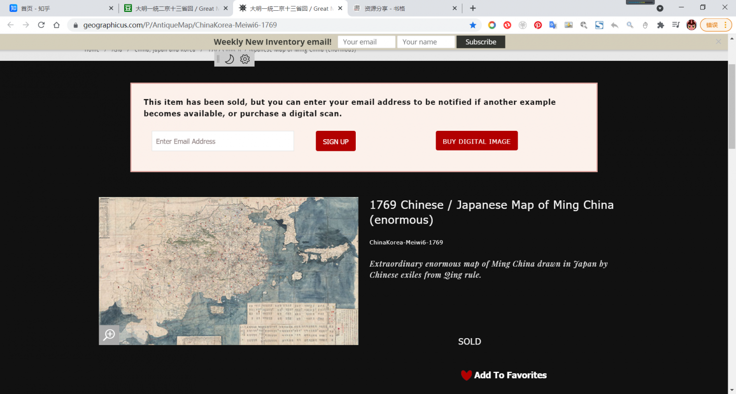
TITLE
大明一統二京十三省図 / Great Ming Unification Two Capitals and Thirteen Provinces Map / Da Ming Yi Yong Er Jing Shi San Shen Tu 1769 (dated) 72 x 122 in (182.88 x 309.88 cm) 1 : 2060000
DESCRIPTION
A previously unknown, monumentally proportioned, and enigmatic Chinese language manuscript map of Ming Dynasty China and Korea prepared on an imposing scale. Measuring a staggering 72 x 122 inches, this is by far the largest single-sheet manuscript map we have worked with. With a focus on China, the map covers from the Andaman Sea to the western shores of Hokkaido and from the Gobi Desert and Mount Paektu (Baekdu or Changbai, North Korea) to the Malay Peninsula (squished up and distorted in the lower left). The map is abundant with rich political and topographical detail including the Great Wall of China, countless towns, roads, trade routes, mountains, and riverways. Throughout there are numerous areas where town names and annotations have been painted over and revised or blocked out with a paste down. The topography throughout China is quite detailed although it becomes less so when focusing on non-Chinese regions such as Korea, Japan, Central Asia, and Malaya. Those who can admire Chinese calligraphy will note that the characters on this map is exceptionally beautiful and well executed.Text in the lower right quadrant states that this map was drawn in Japan in Meiwa 6 or 1769. There appears to be some ambiguity in the text relating to the word 'Nambu,' which could mean either Northern Japan in the vicinity of Hachinohe, or 'Southern Japan' as we interpreted it. Although there is no specific authorship ascribed, based upon the subject matter, style, textual annotations, and and title, we can make certain educated speculations. Following the fall of the Ming Dynasty to the Manchurian Qing in 1644, numerous Ming Chinese scholars, reluctant to live under Qing Manchurian rule, fled to exile in southern Japan, primarily Nagasaki, where they and their descendants had a tremendous influence on Tokugawa Era Japanese thought and religion. This map's focus on Ming China, compounded by the statement that may have been drawn in Southern Japan during the Meiwa period, suggests that it was produced by the descendants of these Chinese exiles or, potentially, their sinophile disciples. Note how the specific route between Ningbo, China, and Nagasaki, Japan, is highlighted with annotation reading '1800 miles to reach Kyushu Coast of Japan' (author's translation). The Ningbo-Nagasaki trade route was the primary route by which Chinese exiles, as well as scholarship, entered Japan. Moreover, the title which includes the term, 大明 (Great Ming), is inherently Chinese and is unlikely to have been applied by a Japanese mapmaker of the Meiwi Period.
The sources for this map are only partially evident but it is noteworthy that the title 大明一統二京十三省図, or Great Ming Unification Two Capitals and Thirteen Provinces, is one generally associated with official Ming Dynasty maps. The use of this specific title was in fact punishable by death under the Qinq. All of this suggest that the map was drawn from official Ming sources secreted into Japan by Chinese exiles fleeing Qing influence. The primary source is most likely the 大明一統 志 (Daming yitong zhi) or Records of the Unity of the Great Ming , a massive Ming geography, compiled in the 1450s, of which only portions survive today. The map also bears some similarity to Ming era maps such as the 大明混一圖 (Da Ming Hun Yi Tu), or Great Ming Amalgamated Map. This is most evident in the form of the China coastline, the course of the Yellow River, the Gobi, and the absence of Taiwan (which did not appear on Chinese maps until the Qing maps of 1708), all of which are suggestive of the Da Ming Hun Yi Tu.
There are several interesting text blocks. One, at the bottom center, bears a list of 44 foreign countries. Many of these are hard to translate, being derived from Arabic, Malay, and other exotic languages, but some are identifiable including Ryukyu (Okinawa), Khmer (Cambodia), Siam (Thailand), Sumatra, Java, Ceylon, and Srivijava (a legendary powerful thalassocratic city-state on Sumatra that exercised influence over most of Southeast Asia).
The text block on the lower right corner features a history of the map starting with the Emperor Hongwu (1368 – 1398), founder of the Ming Dynasty, then the conquest of Mongolia and the Gobi by Emperor Yung Lei (3rd Ming Emperor), the founding of Yunan and Guizhou, and the consolidation of 14 provinces into the traditional Ming 13. It is also here that the map's date of creation, Meiwa 6 (1769), is noted.
The text block just to the left of the history block described above features a list of the 13 provinces of Ming China.
A once in a lifetime discovery. The map is folded into a custom Asian style clamshell box.
DeepL机翻
描述
一幅以前未知的、具有纪念碑式比例的、神秘的明代中国和朝鲜的汉文手稿地图,以惊人的规模编制。这幅地图的尺寸达到了惊人的72 x 122英寸,是迄今为止我们合作过的最大的单张手稿地图。该地图以中国为重点,涵盖了从安达曼海到北海道的西海岸,以及从戈壁滩和白头山(朝鲜的白头山或长白山)到马来半岛(左下角被压扁和扭曲)。该地图有丰富的政治和地形细节,包括中国的长城、无数的城镇、道路、贸易路线、山脉和河道。在整个地图中,有许多地方的城镇名称和注释被涂抹和修改,或者用浆糊涂掉了。整个中国的地形是相当详细的,尽管在关注朝鲜、日本、中亚和马来亚等非中国地区时,它变得不那么详细。那些能够欣赏中国书法的人将会注意到,这幅地图上的字特别漂亮,而且执行得非常好。
右下角的文字指出,这幅地图是在明和6年或者说1769年在日本绘制的。文字中的 "南部"一词似乎有些含糊不清,可能是指八户附近的日本北部,也可能是我们解释的 "日本南部"。虽然没有指定具体的作者,但根据主题、风格、文本注释和标题,我们可以做出某些有根据的推测。1644年明朝落入满清之手后,许多明朝的中国学者不愿意生活在清朝的满洲统治之下,逃到日本南部,主要是长崎流亡,他们和他们的后代对德川时代的日本思想和宗教产生了巨大的影响。这幅地图以明代中国为重点,再加上可能是在明和年间在日本南部绘制的说法,表明它是由这些中国流亡者的后代或可能是他们的慕华门徒绘制的。请注意,中国宁波和日本长崎之间的具体路线是如何被强调的,注释是 "1800里到达日本九州海岸"(作者的翻译)。宁波-长崎的贸易路线是中国流亡者以及学者进入日本的主要路线。此外,包含 "大明 "一词的标题本身就是中国的,不太可能由明和时期的日本地图绘制者使用。
这幅地图的来源只有部分证据,但值得注意的是,大明一统二京十三省図,即大明一统二京十三省,是一般与明朝官方地图有关的标题。事实上,在秦始皇时期,使用这个特定的标题是要被处以死刑的。所有这些都表明,这幅地图是由逃避清朝影响的中国流亡者秘密带到日本的明朝官方资料绘制的。主要来源很可能是《大明一统志》,即《大明一统志》,这是一部庞大的明代地理书,编纂于1450年代,至今只有部分内容存世。该地图还与大明混一图等明代地图有一些相似之处,即大明混一图。这在中国的海岸线、黄河的走向、戈壁以及没有台湾(直到1708年的清朝地图才出现在中国地图上)的形式上最为明显,所有这些都让人联想到《大明混一图》。
这里有几个有趣的文字块。其中,在底部中央,有一份44个外国国家的名单。其中许多是难以翻译的,它们来自阿拉伯语、马来语和其他异国语言,但有些是可以识别的,包括琉球(冲绳)、高棉(柬埔寨)、暹罗(泰国)、苏门答腊、爪哇、锡兰和Srivijava(传说中苏门答腊的一个强大的泰拉索尔式城邦,对大部分东南亚地区都有影响)。
右下角的文字块介绍了地图的历史,从明朝创始人洪武皇帝(1368-1398)开始,然后是永历皇帝(明朝第三任皇帝)对蒙古和戈壁的征服,云南和贵州的建立,以及将14个省合并为传统的明朝13个省。这里还注明了地图的创作日期,即明和六年 (1769年)。
在上述历史区块左侧的文字区块中,有一份明代中国13个省的名单。
这是一个一生中仅有的发现。该地图被折叠在一个定制的亚洲风格的蚌壳盒中。
PS
原始链接 www.geographicus.com/P/Ant...eiwi6-1769
可下载链接 dezoomify.ophir.dev/dezoo...erties.xml
图片可以通过dezoomify下载。但是我的电脑16G内存还是不足以缓存,使用Google Chrome浏览器下载的结果就是Chrome奔溃。
若耶非耶游客谢谢分享!
未曾管理员@键史查询台 #25579
感谢分享。这个在线拼图的无法直接拼图成功和你的内存大小没有关系。受浏览器对 canvas 绘图限制
Chrome: 最大 高度/宽度: 32,767 像素 最大范围: 268,435,456 像素 (例如:16,384 x 16,384) Firefox: 最大 高度/宽度: 32,767 像素 最大范围: 472,907,776 像素 (例如:22,528 x 20,992)
你可以使用dezoomify-rs软件下载
开源说明: github.com/lovas...zoomify-rs
KK游客下载之后,图片却无法保存,浏览器直接崩溃。有下载的朋友分享一下吧。谢谢!
未曾管理员
KK游客十分感谢未曾老师!
西红柿游客我也下完了,用了两天,最后保存的时候浏览器崩溃了。我想问一下,下完了会不会留存在本机得哪个文件夹里面?
键史查询台游客@未曾 #25605
谢谢
大洋国的温斯顿游客链接失效了,请求未曾老师再发一个!
未曾管理员@大洋国的温斯顿 #124047
已补充
大明一统二京十三省图
d5.shuge.org/s/AkLSl
或百度盘
大洋国的温斯顿游客另外向各位群友,未曾老师请教,有无京都大学藏1688年《大明省图》,谢谢
coffine游客@键史查询台 你好,请问 Dezoomif 打开后。这个链接: www.geographicus.com/mm5/g...erties.xml 是怎么得到的,我还想下载这个网站的其他图片,谢谢。
xiaopengyou游客
coffine游客@xiaopengyou 谢谢您的回复
- 作者帖子
正在查看 14 个帖子:1-14 (共 14 个帖子)
正在查看 14 个帖子:1-14 (共 14 个帖子)
正在查看 14 个帖子:1-14 (共 14 个帖子)